$14.95
$11.95
(SAVE Now!)
as of 04/25/2024 (Details)
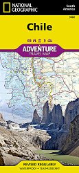
• Waterproof • Tear-Resistant • Travel MapNational Geographic's Chile AdventureMap is designed to meet the unique needs of adventure travelers with its durability and accurate information. This folded map provides global travelers with the perfect combination of detail and perspective, highlighting hundreds of points of interest and the diverse and unique destinations within the country.The map includes the locations of cities and towns with a user-friendly index, plus a clearly marked road network complete with distances and designations for major highways, main roads, and tracks and trails for those seeking to explore more remote regions.The north side of our Chile map covers the Peruvian border south to Concepción, and includes the cities of Santiago, La Serena, Arica, and Chanaral; and the Atacama Desert. Inset maps provide detail for Easter Island, Archipiélago Juan Fernandez, and the San Felix and San Ambrosio Islands. The south side overlaps with the north and covers the remainder of the country—to Cape Horn at the southernmost tip, rich with national parks. Some of the major cities included on this side are Punta Arenas, Concepción, Puerto Montt, and Coihaique.Every AdventureMap is printed on durable synthetic paper, making them waterproof, tear-resistant and tough — capable of withstanding the rigors of international travel. Each is two-sided and can be folded to a packable size of (4.25" x 9.25"); unfolded size is (26" x 38").Key Features:- Waterproof and tear-resistant- Accurate topography/terrain with a clearly labeled road network- Hundreds of points of interest, including the locations parks and nature reserves, protected lands, historical and cultural attractions- Thousands of place names including towns and natural features; detailed place names index- Important travel networks including airports, lighthouses, ferry routes and rail lines- Updated regularly to ensure accuracyProceeds from the sale of National Geographic maps go to support the National Geographic Society's vital exploration, conservation, research and education programs.Map Scale = 1:1,750,000Sheet Size = 37.75" x 25.5"Folded Size = 4.25" x 9.25"
Technical Details
- Used Book in Good Condition