$799.99
$799.99
(SAVE Now!)
as of 04/24/2024 (Details)
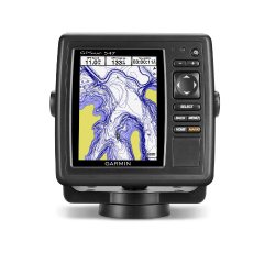
An Amazing Chartplotter 5" VGA display 10 Hz GPS/GLONASS receiver Wireless connectivity U.S. coastal and inland mapping GPSMAP 547 allows for easy visibility, day or night. Whether it is flat, flush or swivel-mounted, it will be the focal point of your helm. It includes our hallmark user-friendly interface as well as U.S. coastal and inland mapping. With the integration of a 10Hz GPS/GLONASS receiver, the 547 refreshes position and heading up to 10 times per second. It displays constant and fluid on-screen location and proves to be incredibly accurate when marking and navigating to any one of 5,000 user-created waypoints. It also has wireless connectivity, giving you the opportunity to connect and access marine-specific apps via smartphone or tablet. Physical & Performance Unit dimensions, WxHxD 5.9" x 6.1" x 2.4" (15.0 x 15.5 x 6.1 cm) Display size, WxH 3.0" x 4.0", 5.0" diagonal (7.6 x 10.2 cm, 12.7 cm diagonal) Display resolution, WxH 480 x 640 pixels Display type VGA display Weight 1.7 lb (0.8 kg) Battery none Battery life none Waterproof Yes (IPX7) High-sensitivity receiver Yes Antenna internal NMEA input/output NMEA 0183 compatible and NMEA 2000® certified Power consumption 0.6A at 12V; 0.3A at 24V 0.8A at 12V; 0.4A at 24V (with sonar) Maps & Memory Basemap Yes Preloaded maps Yes Ability to add maps Yes Built-in memory none (cannot load maps to internal memory) Accepts data cards dual microSD™ card slots Waypoints/favorites/locations 5,000 Routes 100 Track log 50,000 points; 50 saved tracks Features & Benefits Garmin radar compatible No Garmin sonar compatible No Garmin Marine Network™ compatible No Touchscreen No Supports AIS (tracks target ships' position) Yes Supports DSC (displays position data from DSC capable VHF radio) Yes Audible alarms Yes Tide tables Yes Hunt/fish calendar No Sun and moon information Yes 3-D map view Yes (with optional BlueChart g2 Vision card) Auto Guidance Yes (with optional BlueChart g2 Vision card) XM WX Weather & Radio for U.S. & Canada compatible Yes Automatic routing (turn by turn routing on roads) No Voice prompts (e.g. "Turn right in 500 ft.") No Speaks street names (e.g. "Turn right ON ELM STREET in 500 ft.") No Audio/video input/output No Portable No Automotive/motorcycle-friendly No Additional Wireless connectivity: yes HD-ID tracking technology: no Sonar recording: no Connects to a compatible Fusion media system: yes Bluetooth® wireless technology: yes What's in the Box: GPSMAP 547 Power/data cable Tilt/swivel mount Flush mount kit Protective cover Documentation
Technical Details
- With the integration of a 10Hz GPS/GLONASS receiver, the 527 refreshes position and heading up to 10 times per second
- It displays constant and fluid on-screen location and proves to be incredibly accurate when marking and navigating to any one of 5,000 user-created waypoints
- It also has wireless connectivity, giving you the opportunity to connect and access marine-specific apps via smartphone or tablet
- includes worldwide basemap; US BlueChart g2 and US LakeVu HD data card