British Virgin Islands Adventure & Dive Guide Franko Maps BVI Waterproof Map
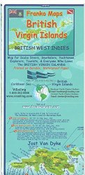
The Franko Adventure & Dive Guide Map of the BVI is loaded with information for everything there is to see and do. The colorful maps have shaded relief on land masses and hues of blue to denote water depths. Side One highlights Jost Van Dyke, Tortola and Virgin Gorda. Inset map of Anegada and detail illustration of the …