National Geographic Maps

Panama (National Geographic Adventure Map)

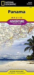
National Geographic’s Panama AdventureMap is designed to meet the unique needs of adventure travelers, highlighting hundreds of points of interest and the diverse and unique destinations within the country.The map includes the locations of cities and towns with a user-friendly index, plus a clearly marked road network complete with distances and designations for major highways, main roads, and …

Learn more

Nicaragua, Honduras, and El Salvador (National Geographic Adventure Map)

• Waterproof • Tear-Resistant • Travel MapNational Geographic’s Nicaragua, Honduras, El Salvador AdventureMap is designed to meet the unique needs of adventure travelers with its durability and accurate information. This folded map provides global travelers with the perfect combination of detail and perspective, highlighting hundreds of points of interest and the diverse and unique destinations within the country.The …

Learn more

Mexico (National Geographic Adventure Map)

• Waterproof • Tear-Resistant • Travel MapNational Geographic’s Mexico AdventureMap is designed to meet the unique needs of adventure travelers with its durability and accurate information. This folded map provides global travelers with the perfect combination of detail and perspective, highlighting hundreds of points of interest and the diverse and unique destinations within the country.The map includes the …

Learn more

Guatemala (National Geographic Adventure Map)

• Waterproof • Tear-Resistant • Travel MapNational Geographic’s Guatemala AdventureMap is the most authoritative map for touring the rich cultural heritage and amazing natural diversity of the Yucatan Peninsula. Each waterproof and tear-resistant map provides travelers with the perfect combination of detail and perspective, highlighting points of interest for those venturing outside city centers.This durable, folded map includes …

Learn more

Caribbean Classic [Laminated] (National Geographic Reference Map)

Completely redesigned and updated, National Geographic Maps’ Caribbean Classic wall map is one of the most authoritative maps for the islands of the Caribbean Sea.This new edition shows the entire region in exceptional detail, with coverage extending from the tip of Florida to the northern extents of Colombia and Venezuela, east to Barbados, and west to the eastern …

Learn more

Baja North: Baja California [Mexico] (National Geographic Adventure Map)

National Geographic’s Baja California North, Mexico AdventureMap is designed to meet the unique needs of adventure travelers, highlighting hundreds of points of interest and the diverse and unique destinations within the country.The map includes the locations of cities and towns with a user-friendly index, plus a clearly marked road network complete with distances and designations for major highways, …

Learn more

Yucatan Peninsula: Riviera Maya [Mexico] (National Geographic Adventure Map)

National Geographic’s Northern Yucatan / Maya Sites, Mexico AdventureMap is designed to meet the unique needs of adventure travelers, highlighting hundreds of points of interest and the diverse and unique destinations within the country.The map includes the locations of cities and towns with a user-friendly index, plus a clearly marked road network complete with distances and designations for …

Learn more

Israel (National Geographic Adventure Map)

• Waterproof • Tear-Resistant • Travel MapNational Geographic’s Israel AdventureMap is designed to meet the unique needs of adventure travelers with its durability and accurate information. This folded map provides global travelers with the perfect combination of detail and perspective, highlighting hundreds of points of interest and the diverse and unique destinations within the country.The map includes the …

Learn more

Moab [Map Pack Bundle] (National Geographic Trails Illustrated Map)

• Waterproof • Tear-Resistant • Topographic MapSeeking the best combination of detailed maps and value for your Moab trip, then get our bundle pack. It includes both our Moab North and Moab South map, providing you coverage of the entire map region. Both maps include detailed trail charts describing the mountain biking and jeep trails that are the …

Learn more

Antarctica Satellite [Laminated] (National Geographic Reference Map)

A striking view of Antarctica’s terrain, compiled from 4,500 satellite scans. Additional inset maps show surface elevation, ice sheet thickness, velocity of ice flow, and sea ice movement and windflow.Map is printed on premium quality paper stock, laminated, rolled, and packaged in a clear plastic sleeve.Map Scale = 1:9,200,000Sheet Size = 31.25″ x …

Learn more