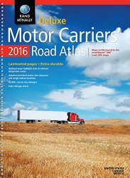
Rand McNally

Rand McNally Signature Map of the World

Updated and redesigned, Rand McNally’s Signature World wall map features eye-catching bold and vivid colors that make this the perfect reference piece sure to stand out in any home, classroom or office. The precise detail and digital accuracy shows color-matching relief and other physical features without sacrificing the maps readability. Printed on high quality paper. World Features:Map centered …

Learn more

Rand McNally TND730 IntelliRoute GPS Truck Navigator

Redesigned inside and out, the Intell iRoute TND 730 LM features new, sleek hardware, a faster processor, and updated graphics and maps, all on a large 7″ screen. Truck Routing Customized for the dimensions of your truck. Set warnings for hills and sharp curves. Navigate complex interchanges with junction view. View current mile marker. Optimize trips with multi-stop …

Learn more

Rand McNally 2016 Large Scale Road Atlas

Give road-weary eyes a break with this spiral-bound Large Scale edition featuring all the accuracy you’ve come to expect from Rand McNally, only bigger. Updated atlas contains maps of every U.S. state that are 35% larger than the standard atlas version plus over 350 detailed city inset and national park maps and a comprehensive, unabridged index. Road construction …

Learn more

Rand McNally 2016 Road Atlas

The Rand McNally Road Atlas is the most trusted and best-selling US atlas on the market. This updated North American atlas contains maps of every U.S. state and Canadian province, an overview map of Mexico, and detailed inset maps of over 350 cities and 20 U.S. national parks. Road construction projects and updates highlighted for every state and …

Learn more

Rand Mcnally Us Wall Map

Wake up your walls with Rand McNally’s colorful, contemporary U.S. Wall Map (rolls out to 50″ x 32″). A combination of bold colors and detailed cartography makes this map stand out in any home, classroom, or office. Features include: Color-matching relief to show mountain ranges and other elevation changes Clearly labeled state and city names for easy location …

Learn more

Rand McNally 2016 EasyFinder Midsize Road Atlas

This spiral bound format features maps that are 35% bigger than those found in Rand McNally’s standard Midsize Atlas. This updated North American atlas contains maps of every U.S. state and Canadian province, an overview map of Mexico, plus detailed maps of over 50 North American cities, all conveniently packaged for travel. Contains mileage chart showing distances between …

Learn more